
Datum and projection help to use map image
OruxMaps :: ENGLISH :: GPS, DATUMS, ETC
Page 1 of 1

Datum and projection help to use map image
![]() JBW Wed Jul 21, 2010 10:07 am
JBW Wed Jul 21, 2010 10:07 am
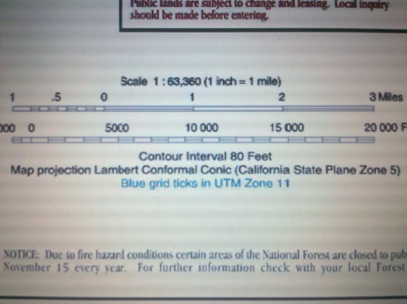
I have an image of a map and I want to use it in orux maps. I understand that I have to look at 2,3 or 4 pixel positions and match them to the the longitude and latitude for those locations. I have done that but am having trouble with what datum and projection to use. The map list projection as lambert conformal conic but when I enter that the program asks for more data which I do not know. Also it says (on the map) that the blue ticks are UTM Zone 11. but it seems like the blue ticks are not what correspond to the coordinates but black ticks? Note: I added the black lines which give me the locations of the 4 points I am matching.
please let me know if I am doing this correctly and any suggestions would be appreciated.
Also If I get datum and projection wrong how far off could I be? I actually do not need more than 50 Meters accuracy but better accuracy would be good.
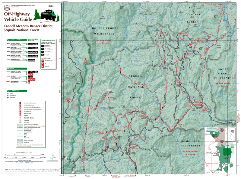
4 points of intersections of the black lines I drew in ( from my understanding the black lines are not really straight but for this level i can make the approximation?)
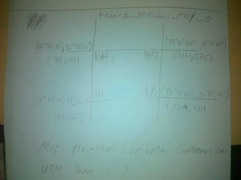
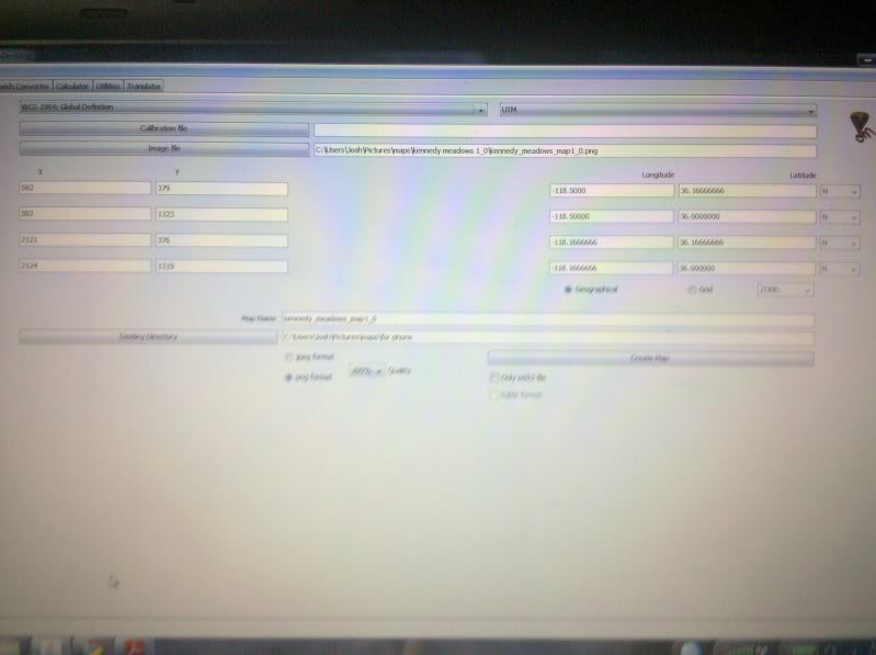
entered into desktop tool (datum and projection need to be corrected but to what?)

Thanks,
Josh
please let me know if I am doing this correctly and any suggestions would be appreciated.
Also If I get datum and projection wrong how far off could I be? I actually do not need more than 50 Meters accuracy but better accuracy would be good.
4 points of intersections of the black lines I drew in ( from my understanding the black lines are not really straight but for this level i can make the approximation?)
entered into desktop tool (datum and projection need to be corrected but to what?)
Thanks,
Josh
JBW- Guest
Re: Datum and projection help to use map image
![]() orux Wed Jul 21, 2010 3:06 pm
orux Wed Jul 21, 2010 3:06 pm
JBW wrote:I have an image of a map and I want to use it in orux maps. I understand that I have to look at 2,3 or 4 pixel positions and match them to the the longitude and latitude for those locations. I have done that but am having trouble with what datum and projection to use. The map list projection as lambert conformal conic but when I enter that the program asks for more data which I do not know. Also it says (on the map) that the blue ticks are UTM Zone 11. but it seems like the blue ticks are not what correspond to the coordinates but black ticks? Note: I added the black lines which give me the locations of the 4 points I am matching.
please let me know if I am doing this correctly and any suggestions would be appreciated.
Also If I get datum and projection wrong how far off could I be? I actually do not need more than 50 Meters accuracy but better accuracy would be good.
4 points of intersections of the black lines I drew in ( from my understanding the black lines are not really straight but for this level i can make the approximation?)
Thanks,
Josh
Hi, Josh;
Nice place
I have found this:
8807. Zone 5 coordinates shall be named, and, on any map on which
they are used, they shall be designated as "CCS27, Zone 5 or CCS83,
Zone 5."
On their respective spheroids of reference: (1) the standard
parallels of CCS27, Zone 5 and CCS83, Zone 5 are at north latitudes
34 degrees 02 minutes and 35 degrees 28 minutes, along which
parallels the scale shall be exact; and (2) the point of control of
coordinates is at the intersection of the zone's central meridian,
which is at 118 degrees 00 minutes west longitude, with the parallel
33 degrees 30 minutes north latitude.
The datum you have to select is: North American 1983 or North American 1927. Try first 1983 datum.
The parameters for Lambert projection are:
Orig. latitude: 33 30.0
Orig. longitude: -118.0
Parallel 1: 34 02.0
Parallel 2: 35 28.0
False East: 0
False North: 0
You can test your maps using the manual you can download here (last page):
http://www.oruxmaps.com/oruxmaps_faa.pdf
orux

orux- Cantidad de envíos : 3946
Fecha de inscripción : 2009-07-06
Thanks
![]() JBW Thu Jul 22, 2010 2:59 am
JBW Thu Jul 22, 2010 2:59 am
The North American 1927 datum seemed to work the best. It is off by about 20 meters but is more than adequate for what I need.
Thanks,
Josh
Thanks,
Josh
JBW- Guest
» New Zealand Datum and Projection
» New Zealand Datum
» Datum and Projection Help needed
» Dutch datum and projection
» How to find datum / projection info of a raster map?
» New Zealand Datum
» Datum and Projection Help needed
» Dutch datum and projection
» How to find datum / projection info of a raster map?
OruxMaps :: ENGLISH :: GPS, DATUMS, ETC
Page 1 of 1
Permissions in this forum:
You cannot reply to topics in this forum|
|
|