
3D shading
+2
Icarus
petesx
6 posters
OruxMaps :: ENGLISH :: IMPROVEMENTS
Page 1 of 1

3D shading
![]() petesx Wed Mar 13, 2013 8:45 pm
petesx Wed Mar 13, 2013 8:45 pm
Hi Orux,
Fantastic app and Thank You!
One request - Could you program shadows in to 3d map view? If there aren't many features on an area of map it's difficult to see the hills and valleys away from the edge of the 3d view.
I think ideally a choice of east or west light source would be great but any low angle light source would make it easier to visualise the change in height.
Thanks in advance,
Pete
petesx- Cantidad de envíos : 5
Fecha de inscripción : 2013-03-13
Re: 3D shading
![]() Icarus Fri Mar 15, 2013 10:32 pm
Icarus Fri Mar 15, 2013 10:32 pm
Hi Orux,
I second petesx on the use of shadows to highlight vertical relief.
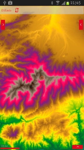
Also as an option you might consider colourised DEM as an effective way to create a map without any cultural features. The screen shots are created from purely DTED data (.hgt or .hdr would work equally well).
This is 2D colourised DTED -

And this is 3D colourised DTED -

The software application in use has the following interface to set colour breakouts -

Something to consider?
I second petesx on the use of shadows to highlight vertical relief.
Also as an option you might consider colourised DEM as an effective way to create a map without any cultural features. The screen shots are created from purely DTED data (.hgt or .hdr would work equally well).
This is 2D colourised DTED -
And this is 3D colourised DTED -
The software application in use has the following interface to set colour breakouts -
Something to consider?
Icarus- Cantidad de envíos : 104
Fecha de inscripción : 2011-04-03
Re: 3D shading
![]() orux Wed Mar 20, 2013 9:32 pm
orux Wed Mar 20, 2013 9:32 pm
Icarus wrote:Hi Orux,
I second petesx on the use of shadows to highlight vertical relief.
Also as an option you might consider colourised DEM as an effective way to create a map without any cultural features. The screen shots are created from purely DTED data (.hgt or .hdr would work equally well).
This is 2D colourised DTED -
And this is 3D colourised DTED -
The software application in use has the following interface to set colour breakouts -
Something to consider?
We are near
orux

orux- Cantidad de envíos : 3946
Fecha de inscripción : 2009-07-06
Re: 3D shading
![]() Icarus Sat Mar 23, 2013 12:54 am
Icarus Sat Mar 23, 2013 12:54 am
Great job on the Relief Map! The only suggestion is that 0' elevations are rendered in blue to better delineate sea/coast.

There will be irregular areas where this doesn't work well (Netherlands perhaps?), but overall should give good coastline definition.
There will be irregular areas where this doesn't work well (Netherlands perhaps?), but overall should give good coastline definition.
Icarus- Cantidad de envíos : 104
Fecha de inscripción : 2011-04-03
Re: 3D shading
![]() TheDuke Sat Mar 23, 2013 11:19 am
TheDuke Sat Mar 23, 2013 11:19 am
orux wrote:Icarus wrote:Hi Orux,
I second petesx on the use of shadows to highlight vertical relief.
Also as an option you might consider colourised DEM as an effective way to create a map without any cultural features. The screen shots are created from purely DTED data (.hgt or .hdr would work equally well).
This is 2D colourised DTED -
And this is 3D colourised DTED -
The software application in use has the following interface to set colour breakouts -
Something to consider?
We are near
orux
Hallo,
What is that ? Fraktal Graphics ?
For what can i need this

Who need this, he can make a map with this view.
TheDuke
TheDuke- Cantidad de envíos : 41
Fecha de inscripción : 2012-01-09
solar shading
![]() captain paranoia Fri May 17, 2013 12:44 pm
captain paranoia Fri May 17, 2013 12:44 pm
Having been playing with OruxMaps for a couple of weeks, firstly, I would like to say 'bravo! a fantastic piece of work', and secondly, I'd also like to see 3D relief shading, in particular solar shading, and this makes reading relief a lot easier.
I've played with solar shading using LandSerf in the past, and have merged OSGB mapping images and solar relief shading to create composite, relief-shaded map tiles, using a very manual process. The problem with raster images is, of course, that we need to be able to add shading for the relief, and this shading can obscure the map detail, or, if the map is superimposed on the relief, the raster image can obscure the shading. I used transparency settings in raster GIF tiles, setting the background 'white' of the OSGB map tiles to be the transparent colour, and laid these tiles over a grey-scaled solar relief image from LandSerf. Here's an example:

As you can see, it's far from perfect, as the transaprency detection doesn't work perfectly (due to the aliasing on edges), and areas of solid colour (such as the woodland) obscure the relief shading. But it's not too bad.
Solar relief shading is quite computationally intensive; probably about the same as generating relief mapping or 3D terrain modelling, but you manage to do both of those quite well
I guess one way of achieving this would be to allow dynamic merging of mapping layers, with transparency control (i.e. displaying 3d_relief and cartographic tiles, either in real time, or from cache).
I've played with solar shading using LandSerf in the past, and have merged OSGB mapping images and solar relief shading to create composite, relief-shaded map tiles, using a very manual process. The problem with raster images is, of course, that we need to be able to add shading for the relief, and this shading can obscure the map detail, or, if the map is superimposed on the relief, the raster image can obscure the shading. I used transparency settings in raster GIF tiles, setting the background 'white' of the OSGB map tiles to be the transparent colour, and laid these tiles over a grey-scaled solar relief image from LandSerf. Here's an example:
As you can see, it's far from perfect, as the transaprency detection doesn't work perfectly (due to the aliasing on edges), and areas of solid colour (such as the woodland) obscure the relief shading. But it's not too bad.
Solar relief shading is quite computationally intensive; probably about the same as generating relief mapping or 3D terrain modelling, but you manage to do both of those quite well
I guess one way of achieving this would be to allow dynamic merging of mapping layers, with transparency control (i.e. displaying 3d_relief and cartographic tiles, either in real time, or from cache).
captain paranoia- Cantidad de envíos : 9
Fecha de inscripción : 2013-05-17
sun angle
![]() captain paranoia Fri May 17, 2013 12:53 pm
captain paranoia Fri May 17, 2013 12:53 pm
ps. OSGB used to print 'Tourist Maps', which had solar shading, and they used a sun position of 315 degrees. Which you will never get in the UK...
Whilst playing with LandSerf, I tried different sun angles, but I found that the OS had got it right; 315 degrees gives a picture that 'looks right'. I notice the earlier examples on this page also used 315 degrees. The brain is a funny thing...
Whilst playing with LandSerf, I tried different sun angles, but I found that the OS had got it right; 315 degrees gives a picture that 'looks right'. I notice the earlier examples on this page also used 315 degrees. The brain is a funny thing...
captain paranoia- Cantidad de envíos : 9
Fecha de inscripción : 2013-05-17
Re: 3D shading
![]() captain paranoia Mon Jul 08, 2013 4:56 pm
captain paranoia Mon Jul 08, 2013 4:56 pm
> OSGB used to print 'Tourist Maps', which had solar shading, and they used a sun position of 315 degrees. Which you will never get in the UK...
Hmmm... that's not necessarily true. I had foolishly thought that the sun never rises above the W-E meridian, but I realised that's wrong when I remembered where the sun rises on summer mornings; to the north of my house... So I thought about it a bit, and it became very obvious. Then I found a nice website that gives sun rise/fall times, and plots the bearings on GoogleMaps:
NOAA sunrise/sunset calculator
captain paranoia- Cantidad de envíos : 9
Fecha de inscripción : 2013-05-17
Phong shading
![]() borish Thu Aug 22, 2013 8:34 pm
borish Thu Aug 22, 2013 8:34 pm
You could use the DEM data to compute normal vectors, then compute the scalar product between the normal and a light vector and use Phong shading. This is easy to implement and quite fast.
borish- Cantidad de envíos : 7
Fecha de inscripción : 2013-08-08
OruxMaps :: ENGLISH :: IMPROVEMENTS
Page 1 of 1
Permissions in this forum:
You cannot reply to topics in this forum|
|
|