
2.6.0 in the market
2 posters

2.6.0 in the market
![]() orux Fri Apr 09, 2010 3:54 pm
orux Fri Apr 09, 2010 3:54 pm
Hello all;
There is a new beta with significant changes and improvements.
At the end we're going to skip version 2.4 because 2.6 has advanced faster than expected:)
What is new is the 2.5.3beta?
-> WE HAVE MORE ONLINE SOURCES OF MAPS (google, microsoft, ....,
-> The great thing is that maps are stored in a database on sd, for use offline.


The changes are:
-> On the main screen by selecting 'Online Maps' leads to the last map used online, by default google maps.
-> In the menu there are two options:
--------->Maps (maps offline always)
--------->@Maps, with new online sources. We can go from offline to online maps without any problems, and vice versa.
MOST IMPORTANT: In the folder / oruxmaps / mapfiles / there is a database with cached maps: OruxMapsCacheImages.db
It is an important file, which if corrupted (can happen) you lose the cached images. When we have many maps, you should make a backup.
THERE ARE TWO thresholds (SETTINGS - ONLINE MAPS):
- HIGHER THRESHOLD: megas from which OruxMaps advise that you have a very large database (by default, 512 mb).
- LOWER THRESHOLD is the size that will have the database after compact it.
This can take a lot of time (minutes, many). MAKE A BACKUP BEFORE YOU DO IT, just in case!
Here that this beta :---->http://www.oruxmaps.com/OruxMaps2.5.7beta.apk
Remember this is a BETA, it may fail, and if it fails, it is very important that you tell me to correct mistakes. And if you have the program installed aLogcat, and after a failure of the application you send me the log generated by this program the better.
NEW 2.5.5beta:
---> In settings - application, two new options:
-> Keys volume, you can select digital zoom or normal zoom.
-> Zoom preset, useful for nexus and other high-resolution screen, you can pre-configure to always load maps with various levels of digital zoom.
IMPORTANT: The first thing is to make a backup of the file oruxmapstracks.db found in the directory oruxmaps/tracklogs/
It is the database of tracks, the new version makes changes in its structure. It should not happen anything, but just in case ,....
NEW 2.3.4BETA--->
-->new zoom management (multilayer maps): VOLUME KEYS--> always digital zoom.
NEW BETA 2.3.3---->
-SOLVES SOME BUGS
-AUTOMATIC WPT CREATION (SETTINGS--APPLICATION)
-SOME TEST ICONS FOR WPTS (PHOTO, BAR, AIRPORT, CACHE, WATER)
-WPTS WITHOUT ICON
BETA VERSION----->http://www.oruxmaps.com/OruxMaps2.3.4beta.apk
What's New:
------>New way to create Waypoints.
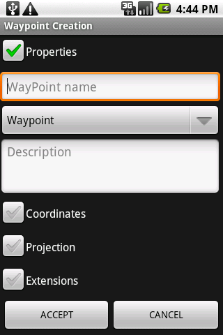

Now when you create a wpt you can:
-> Modify their coordinates/altitude.
-> Create a wpt from the current position plus a distance and a bearing.

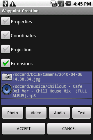
-> You can attach a picture/video/audio/ text to the wpts. If you attach an audio, and the wpt. alarm is enabled, you will hear the attached audio files. You can see the sounds/images/videos when you see the characteristics of the wpts.
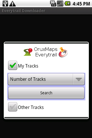
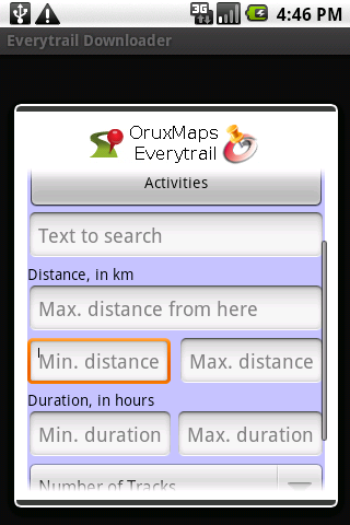
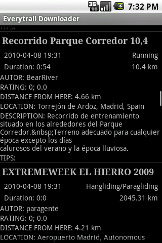
-----> Download/search tracks at everytrail.com. You can download both your tracks, such as searching others. Criterias of search: the type of activity, distance to current position, time duration and length of the route. IMPORTANT: To search for other tracks is not necessary to have an account in everytrail.com
------> Supported one file per map (experimental) created with the attached version of Mobile Atlas Creator. Simply select "OruxMaps Sqlite" and create a map with all the images inside a file. It should work exactly the same as they were before; copy the map folder on the sd of your mobile.
TEST VERSION--->http://www.oruxmaps.com/MobileAtlasCreator1.8alpha5OruxMapsTest.zip
SOURCE CODE OF THIS VERSION--->http://www.oruxmaps.com/MobileAtlasCreator1.8alpha5OruxMapsTestSrc.zip
------> Other minor changes.
The usual, Awaiting your comments/errors.
I need your feedback as to whether the new features work well!!
orux
There is a new beta with significant changes and improvements.
At the end we're going to skip version 2.4 because 2.6 has advanced faster than expected:)
What is new is the 2.5.3beta?
-> WE HAVE MORE ONLINE SOURCES OF MAPS (google, microsoft, ....,
-> The great thing is that maps are stored in a database on sd, for use offline.
The changes are:
-> On the main screen by selecting 'Online Maps' leads to the last map used online, by default google maps.
-> In the menu there are two options:
--------->Maps (maps offline always)
--------->@Maps, with new online sources. We can go from offline to online maps without any problems, and vice versa.
MOST IMPORTANT: In the folder / oruxmaps / mapfiles / there is a database with cached maps: OruxMapsCacheImages.db
It is an important file, which if corrupted (can happen) you lose the cached images. When we have many maps, you should make a backup.
THERE ARE TWO thresholds (SETTINGS - ONLINE MAPS):
- HIGHER THRESHOLD: megas from which OruxMaps advise that you have a very large database (by default, 512 mb).
- LOWER THRESHOLD is the size that will have the database after compact it.
This can take a lot of time (minutes, many). MAKE A BACKUP BEFORE YOU DO IT, just in case!
Remember this is a BETA, it may fail, and if it fails, it is very important that you tell me to correct mistakes. And if you have the program installed aLogcat, and after a failure of the application you send me the log generated by this program the better.
NEW 2.5.5beta:
---> In settings - application, two new options:
-> Keys volume, you can select digital zoom or normal zoom.
-> Zoom preset, useful for nexus and other high-resolution screen, you can pre-configure to always load maps with various levels of digital zoom.
IMPORTANT: The first thing is to make a backup of the file oruxmapstracks.db found in the directory oruxmaps/tracklogs/
It is the database of tracks, the new version makes changes in its structure. It should not happen anything, but just in case ,....
NEW 2.3.4BETA--->
-->new zoom management (multilayer maps): VOLUME KEYS--> always digital zoom.
NEW BETA 2.3.3---->
-SOLVES SOME BUGS
-AUTOMATIC WPT CREATION (SETTINGS--APPLICATION)
-SOME TEST ICONS FOR WPTS (PHOTO, BAR, AIRPORT, CACHE, WATER)
-WPTS WITHOUT ICON
BETA VERSION----->http://www.oruxmaps.com/OruxMaps2.3.4beta.apk
What's New:
------>New way to create Waypoints.
Now when you create a wpt you can:
-> Modify their coordinates/altitude.
-> Create a wpt from the current position plus a distance and a bearing.
-> You can attach a picture/video/audio/ text to the wpts. If you attach an audio, and the wpt. alarm is enabled, you will hear the attached audio files. You can see the sounds/images/videos when you see the characteristics of the wpts.
-----> Download/search tracks at everytrail.com. You can download both your tracks, such as searching others. Criterias of search: the type of activity, distance to current position, time duration and length of the route. IMPORTANT: To search for other tracks is not necessary to have an account in everytrail.com
------> Supported one file per map (experimental) created with the attached version of Mobile Atlas Creator. Simply select "OruxMaps Sqlite" and create a map with all the images inside a file. It should work exactly the same as they were before; copy the map folder on the sd of your mobile.
TEST VERSION--->http://www.oruxmaps.com/MobileAtlasCreator1.8alpha5OruxMapsTest.zip
SOURCE CODE OF THIS VERSION--->http://www.oruxmaps.com/MobileAtlasCreator1.8alpha5OruxMapsTestSrc.zip
------> Other minor changes.
The usual, Awaiting your comments/errors.
I need your feedback as to whether the new features work well!!
orux
Last edited by orux on Mon May 17, 2010 4:37 pm; edited 8 times in total (Reason for editing : 2.6.0 in the market)

orux- Cantidad de envíos : 3946
Fecha de inscripción : 2009-07-06
Re: 2.6.0 in the market
![]() brotbuexe Thu Apr 15, 2010 5:12 am
brotbuexe Thu Apr 15, 2010 5:12 am
no problems with the sqlite. Tested a aera with 90x90km and created some sqlite files with up to 650 MB. great work.
brotbuexe- Cantidad de envíos : 17
Fecha de inscripción : 2010-04-13
digital zoom
![]() brotbuexe Sat Apr 17, 2010 9:04 pm
brotbuexe Sat Apr 17, 2010 9:04 pm
love and hate the new digital zoom on volume keys.
love it because on n1 the ppi is too high for openstreetmap tiles.
hate it because i use the volume keys for zooming on bicycle (using fullfinger gloves).
would suggest to make it configurable.
and a button, or a menu under "menu / options" with some digital zoom levels to select, to make a digital zoom for all tile zoom levels. so all tile zoom levels have for example 2x or 4x digital zoom.
so i can setup a 4x digital zoom when on bicycle and no digital zoom when i have the phone in my hands.
Sven
brotbuexe- Cantidad de envíos : 17
Fecha de inscripción : 2010-04-13
Re: 2.6.0 in the market
![]() orux Sun Apr 18, 2010 7:05 pm
orux Sun Apr 18, 2010 7:05 pm
brotbuexe wrote:love and hate the new digital zoom on volume keys.
love it because on n1 the ppi is too high for openstreetmap tiles.
hate it because i use the volume keys for zooming on bicycle (using fullfinger gloves).
would suggest to make it configurable.
and a button, or a menu under "menu / options" with some digital zoom levels to select, to make a digital zoom for all tile zoom levels. so all tile zoom levels have for example 2x or 4x digital zoom.
so i can setup a 4x digital zoom when on bicycle and no digital zoom when i have the phone in my hands.
Sven
Ok, I will study your suggestion.
orux
orux- Cantidad de envíos : 3946
Fecha de inscripción : 2009-07-06
Re: 2.6.0 in the market
![]() jogger Mon Apr 19, 2010 5:41 pm
jogger Mon Apr 19, 2010 5:41 pm
Is there a way to create map of irregularly shaped regions (i.e. any real region that is not exactly a rectangle)?
For example, if I only want a map of New York city, I'm forced to include the nearby water (which are just useless blue images that takes up space...) because NYC is not quite rectangularly shaped... It would be great if I can combine several rectangular regions into a single map (instead of having to create NYC1, NYC2, etc... for each rectangular region).
Thanks.
jogger- Guest
Re: 2.6.0 in the market
![]() jogger Mon Apr 19, 2010 6:05 pm
jogger Mon Apr 19, 2010 6:05 pm
What I more or less think is, instead of having folder structure
/sdcard/oruxmaps/mapfiles/:
- Europe Map
- US map
- NYC region1 map
- NYC region2 map
...
I would love to see
/sdcard/oruxmaps/mapfiles/:
- Europe Map
- US map
- NYC map
- NYC region1 map
- NYC region2 map
...
And whenever I choose a map, I would be presented with choices (Europe map, US map, NYC map) instead of (Europe mmap, US map, NYC region1 map, NYC region2 map).
If you would like, this is more or less an eye candy kind of thing
/sdcard/oruxmaps/mapfiles/:
- Europe Map
- US map
- NYC region1 map
- NYC region2 map
...
I would love to see
/sdcard/oruxmaps/mapfiles/:
- Europe Map
- US map
- NYC map
- NYC region1 map
- NYC region2 map
...
And whenever I choose a map, I would be presented with choices (Europe map, US map, NYC map) instead of (Europe mmap, US map, NYC region1 map, NYC region2 map).
If you would like, this is more or less an eye candy kind of thing
jogger- Guest
Re: 2.6.0 in the market
![]() orux Mon Apr 19, 2010 7:12 pm
orux Mon Apr 19, 2010 7:12 pm
jogger wrote:Is there a way to create map of irregularly shaped regions (i.e. any real region that is not exactly a rectangle)?
For example, if I only want a map of New York city, I'm forced to include the nearby water (which are just useless blue images that takes up space...) because NYC is not quite rectangularly shaped... It would be great if I can combine several rectangular regions into a single map (instead of having to create NYC1, NYC2, etc... for each rectangular region).
Thanks.
Hi, jogger;
Not posible with current version of Mobile atlas creator; but I am thinking in a solution for future versions,
orux
orux- Cantidad de envíos : 3946
Fecha de inscripción : 2009-07-06
jogger- Guest
sqlite support is a great feature
![]() newnaw Mon May 17, 2010 6:50 am
newnaw Mon May 17, 2010 6:50 am
Loving "Supported one file per map (experimental) created with the attached version of Mobile Atlas Creator."~~
It'll be perfect if the mobac file on could including the "Oruxmaps sqlite" option~
It'll be perfect if the mobac file on could including the "Oruxmaps sqlite" option~
newnaw- Guest
Re: 2.6.0 in the market
![]() Uli Tue May 18, 2010 2:03 pm
Uli Tue May 18, 2010 2:03 pm
Works great with the N1.
It gives us a good chance to get some more maps in an internet-cafe, when we are on holiday without a PC.
The only reason to get the maps per PC is the chance to edit them for a better contrast, that helps you outdoor in the sunshine
Nice job so far, please get on!
It gives us a good chance to get some more maps in an internet-cafe, when we are on holiday without a PC.
The only reason to get the maps per PC is the chance to edit them for a better contrast, that helps you outdoor in the sunshine
Nice job so far, please get on!
Uli- Guest
» 3.2.6 in the market
» 2.6.0 en el market
» EN EL MARKET V.1.4.0!!!!
» 3.0 in the market
» OruxMaps v.1.8 (en el Market)
» 2.6.0 en el market
» EN EL MARKET V.1.4.0!!!!
» 3.0 in the market
» OruxMaps v.1.8 (en el Market)
Permissions in this forum:
You cannot reply to topics in this forum|
|
|